Lancang-Mekong Economic Zones

Economic zone details


Name 
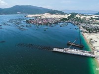
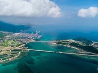
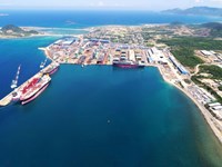
Van Phong Coastal Economic Zone
Location Open in Google Map
Province Khanh Hoa Province
Country Vietnam
Photos   
Overview of the EZ

Van Phong Economic Zone was established by the Prime Minister under Decision No. 92/2006/QD-TTg dated April 25th 2006 with total area of 150,000 ha (about 70,000 ha of land and 80,000 ha of water surface), locates in Van Ninh district and Ninh Hoa town, Khanh Hoa province, belongs to the South Central Coast area of Viet Nam.

On March 17th 2014, Prime Minister issued the Decision 380/QD-TTg approving the adjusted master plan of Van Phong Economic Zone in Khanh Hoa province toward 2030 with properties:

  • Being an economic zone of multi-sector, multi-industry. In which, international transhipment port, oil refining industry, oil transshipment and petrochemical industry keep the leading role; associate with developing tourism, services, industry, aquaculture and other economic sectors.
  • As the economic center of the Khanh Hoa province, plays the leading role to attract investment and becomes the motivation to develop the economy of the neighborhood and the whole country.

Van Phong Economic Zone mainly concentrated in two areas: South Van Phong (in Ninh Hoa town) and North Van Phong (in Van Ninh district).

Location:

Van Phong EZ locates in the North of Khanh Hoa:

  • To HCM City: about 500 km.
  • To Hanoi: about 1,200 km.
  • About 30 km north of Nha Trang city (center of Khanh Hoa province).
  • To Cam Ranh international airport: about 65 km south of the economic zone.
  • To Tuy Hoa airport - Phu Yen province: about 40 km north of the economic zone.
Location Advantage

- National Highway 1A and the North-South railway run along the Economic Zone.

- Van Phong bay has an average depth of 20-27 m, airtight, locates near the international maritime routes, very convenient to build an international transshipment port and to develop marine economic sectors.

- This location is the gateway to the East Sea for the Central Highlands to develop East-West Economic Corridor. The distance to the East Sea is the closest to Central Highlands (130km).

- Some industrial large-scale projects are operating effectively  at South Van Phong area: (Hyundai-Vinashin Shipyard, Van Phong Bonded Petroleum Terminal), implementing investment procedures (Thermal Power Plant Van Phong 1 BOT project, Nam Van Phong Petrochemical complexes, Nam Van Phong general port, Ninh Thuy industrial zone).

- Beautiful scenery, diverse ecosystem, mild climate are very good conditions to develop tourism.

Website https://vanphong.khanhhoa.gov.vn/chuc-nang-nhiem-vu.html
Year of Establishment 25/4/2006
Total Area of the Zone 150,000 Hectares
EZ Authority and Contact Address

Mr. Hoang Dinh Phi- Head of Van Phong EZ (2018)

Address: 06 Le Thanh Phuong street - Nha Trang city - Khanh Hoa province

Phone: 0583.560.494 | Fax: 0583.560.494

Email: bqlvp@khanhhoa.gov.vn

Website: vanphong.khanhhoa.gov.vn


Major Roads

Roads: National Highway 1A and 26B, Provincial Route 1A and 1B, road from Highway 1A to Ninh Hai connect all functional zones in South Van Phong area, main road from Highway 1A (Co Ma Pass) to Van Phong international transshipment port

Railway Network

Railway: North-South railway runs along Van Phong EZ

Nearest Airports

Airway: to Cam Ranh international airport about 65km south of the economic zone, to Tuy Hoa airport in Phu Yen province about 40 km north of the economic zone.

Any Other Transportation

Seaways: South Van Phong general port (30,000 DWT) locates adjacent to Ninh Thuy industrial zone; North Van Phong general port (50,000 DWT) in Dam Mon; Hon Khoi port (3,000 DWT) and other specialized ports.

Electrical Price per Unit

- Power supply: Electricity from the national grid via 220KV station Tuy Hoa - Nha Trang; 110KV station in Ninh Thuy industrial zone; 35KV grid is installed in the area of ​​international transshipment port.

- Communications systems, human resources, resettlement zones are ready to meet the needs of investors.

Water Supply System

 Water supply: water supply systems from Da Ban lake (75 million m3); Tien Du lake (9 million m3); Dong Dien lake (100 million m3); Hoa Son lake (19 million m3).


Lancang-Mekong Economic Zones

An information sharing platform for stakeholders, beneficiaries and investors within and outside Lancang-Mekong region