| Overview of the EZ |
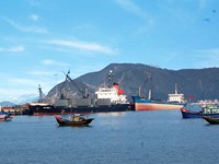
Hon La Economic Zone ((in Vietnamese): Khu kinh tế Hòn La) is one of special economic zones in Vietnam. This zone is located by the South China Sea's Hon La Port in Quảng Trạch District, Quảng Bình Province, Bắc Trung Bộ, Vietnam. The economic zone covers 100 square kilometers, including communes: Quảng Đông, Quảng Phú, Quảng Tùng, Cảnh Dương, Quảng Hưng and Quảng Xuân.
Hon La Economic Zone is situated 60 km north Đồng Hới, around 440 km south of Hanoi, at the foot of Ngang Pass, near the Vung Ang Economic Zone in Hà Tĩnh Province with deep-water Vung Ang Port. The National Route 1A and Vietnamese main railway runs along the zone.
The economic zone is accessed by road, railway at Đồng Hới Railway Station or by air at Đồng Hới Airport (54 km south) or Phu Bai International Airport (220 km south).
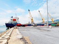
In order to attract investment here, preferentially reduced taxes, fees, land hire and investment incentives are applied to investors. As of 2009, Petrovietnam is operating a deep-water Hon La Port (a port capable to serve 10,000 metric tonne vessels, full capacity will reach up to 12 million metric tonnes of cargoes per annum). Petrovietnam is preparing to build a 2,400 MW coal-fuelled thermal power plant (Quang Trach Thermal Power Plant, total estimate is $1.5 billion) in this economic zone.
CONSTRUCTION PLAN OF HON LA ECONOMIC ZONE – QUANG BINH PROVINCE TO 2030
1. Boundary, area
Planned zone covers an area of 10,000 ha, including area of island and sea, geographical boundaries are defined as follows:
- Bordering Ha Tinh province in the north;
- Bordering Quang Tho commune, Quang Trach district in the south;
- Bordering communes of Quang Kim, Quang Chau, Quang Tien, Quang Luu, Quang Phuong and Quang Long in Quang Trach district;
- Bordering East sea in the east.
2. Characteristics
- Being a multi-branch, multi-disciplinary economic zone, including: industry - seaport - trade - services - travel - urban and agriculture, forestry, fisheries;
- Being an economic center of Quang Binh province with modern and synchronous urban infrastructure; having a leading role to attract investment and being development driving force for other areas.
3. Population scale
- To 2020: around 58,000 people;
- To 2030: around 76,000 people.
4. Land using plan
4.1. Land area for non-tariff zone: 36.0 ha.
4.2. Land area for tariff zone: 9,964 ha,
- Land area for construction of functional zones: port, industry, tourism, urban area, infrastructures ...: 3,189.4 ha. Out of which:
+ Land area for ports: 133 ha;
+ Land area for concentrated industrial parks: 1,353.5 ha;
+ Land area for tourism zones: 3,96.96 ha (ecotourism zone of Vung Chua – Yen island, ecotourism sites and cultural, historic relics: Vinh Son temple, Lieu Hanh princess temple...);
+ Land area for urban and functional zones: 1,257.8 ha.
- Land area for rural residential zones and agro-ecological zones: 5,761.9 ha. Out of which, rural residential zones: 247.6 ha.
- Area of island and sea: 1,012.7 ha.
5. Development orientation of spatial and functional areas
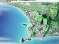
5.1. Spatial development structure is under 03 main traffic routes include highway 1A, west road coastal road; concentrated development areas stick closely on port zone in north economic zone, out of which, Hon La deep-sea port is nucleus of economic zone. Industrial parks are located in convenient transport location. Urban and tourism zones are located near coastal area. High tech agro ecological and tourism development areas are located in south Roon river. Land area for military are retained to serve national security requirements. High mountain and hill areas are for development of afforestation and forest ecology.
5.2. Functional areas
- Non-tariff zone
- Tariff zone
|
| Zone and Area (repetition) |
Functional areas
- Non-tariff zone: locating closely to key road to synthesis port which is convenient for external economic activities, covering an area of approximately 36 ha.
- Tariff zone:
+ Industry: Total land area for industrial construction of Hon La economic zone is about 1,486.5 hectares, including Hon La port with an area of 133 ha in commune of Quang Dong; sea port industrial park in commune of Quang Dong with a scale of 613.5 ha; Industrial park No. 2 in Quang Phu commune with a scale of about 485 ha; Industrial cluster of salt production and seafood processing with a scale of about 90 ha; industrial park with a scale of about 118 ha in west gate of the economic zone and industrial cluster in south gate of economic zone with a scale of 47 ha;
+ Urban residential area: total land area for urban construction of Hon La economic zone is around 754 hectares, including 6 areas (including new residential area and resettlement area): resettlement area No.1 in north highway 1A and resettlement area No.2 in north mountain of Tho Son with a scale of about 51 ha; new urban area and resettlement area No.3 in south non-tariff areas with a scale of 108 ha; new urban areas and resettlement area No.4 in north Roon river with a scale of 225 ha. New urban areas and resettlement area No.5 in north Roon river and salt field of Quang Phu with a scale of about 110 ha. New urban areas and resettlement area No.6 in south Roon river and east highway 1A in communes of Canh Duong and Quang Hung with a scale of about 260 ha;
+ Rural residential area: old village areas, upgrading and improving transport infrastructure, raising people's living. House model are a garden house, villa, mainly locating in Quang Tung, Quang Hung, Quang Xuan communes;
+ Ecology tree and tourism zone: locating along coast, along river, hill and water surface to create landscapes and improve microclimate for economic zone, including: tourism zone of Lieu Hanh princess relic with an area of approximately 38.4 hectares; tourism zone of Vung Chua - Yen island; Dong Hung sea ecotourism zone with a scale of around 30 hectares; sea eco-tourism zone in north resettlement area with a scale of about 22.7 hectares and along coast in the south with a scale of about 269 ha;
+ Agricultural zone: having an area of 1,169 hectares, planting food crops towards intensive-cultivation, enhancing food crops, fresh vegetables, premium vegetable for new urban zone, tourism zone ... Developing garden and farming economic to grow fruit trees and ornamental plants;
+ Forest area: maintaining an area 2848 ha of forest land on environmental protection, timber exploitation and development of mountainous ecotourism. Boosting to plant coastal protection trees against wind and sand, planting concentrated forest on existing mountains to form green belt of protecting the economic zone;
+ Land area for construction of key infrastructure projects, including: Hon La general and specialized port with a size of about 140 ha, stations of electricity, waste water treatment, solid waste treatment, water supply with an area of approximately 20 hectares;
+ Military zone: focusing on high points of Quang Dong commune with a scale of about 430 ha.
|


